- Reject gas tax increases. Twenty cents a gallon was good enough for 1988, it's good enough for 2007! ("An unnecessary and onerous burden" he called the proposed 7.5 cent per gallon tax in May, vetoing a bill which also mandated annual bridge inspections; in 2005, he asked "How dumb can they be?" of Democratic legislators proposing a gas tax increase; in early 2007 he accused them of being "having been simply obsessed with a gas tax"; the GOP Minority Leader in the House this spring called the gas tax proposal "a joke" and a "pocket picking mechanism" but now, with a bridge collapsed and several dead or missing, is open to ideas. Also, our Governor's hopes to be Number Two on the Straight Talk Express appear to have been derailed now that McCain is flying coach and carrying his own bags, staying in the race just long enough to collect matching public funds to pay off campaign debts.)
- Defer projects and maintenance. I personally like how the bid for the Crosstown Commons rebuild required the contractors to loan the state the money for a year until we could afford to pay for it. Unsurprisingly, nobody bid, and the project was delayed a year.
- Wait Until Things Get Bad. As you may have heard, a main Interstate Highway bridge collapsed Wednesday during rush hour near downtown Minneapolis. At the moment, the official toll is 5 dead and 8 missing, though I'd be amazed if this doesn't get bigger.
- Compare this Catastrophe to 9/11 and Katrina. Hmmm, wasn't that about 3,000 and 1,200 dead, as compared to 5? Still, we've got some great visuals!
- Er, Let's Hold Off on that New Twins Stadium Groundbreaking, shall we? Bud Selig was going to be here Thursday for this celebration, but it seemed a bit tasteless even for him to celebrate a taxpayer-financed ballpark the day after a taxpayer-owned bridge had collapsed.
- Get Money from the Feds. Helps to have one of our representatives as head of the House Transportation Committee, it looks like $250 million is headed our way. Maybe, with luck, the new bridge will be in place in time for the opening of the new taxpayer-financed Twins stadium and the new taxpayer-financed University of Minnesota Gophers football stadium. Give credit to the Gophers football team, though, they have gotten us used to historic collapses.
- Get a visit from the President. President Bush was here this morning, looking solemn and wearing a hard hat and, in contrast to a couple of days ago, able to pronounce our Governor's last name. His trainers must have been hard at work. We're promised an expedited effort to rebuild the bridge (I'm guessing it won't be to the original plans). One wonders if this has to do with the Republican National Convention to be held here just about a year from now. Not going to look so good, this big hole in the transportation fabric.
Very savvy. If he'd listened to those obsessive dumb jokers in the legislature we'd have higher gas taxes and be using money picked from the pockets of hard-working Minnesota taxpayers to patch up this structurally deficient bridge. Now, we'll get a nice shiny new bridge paid for by the Feds! Exchange 5 dead for $250 million and the chance to look concerned and solemn in front of a photogenic structural collapse. Perhaps there are those who think this is an ok deal. I don't.
How Close Were We?
Had the bridge hung on another 15 or 20 minutes, it could have been us. We were on our way, all four of us, to a concert at Orchestra Hall in downtown Minneapolis. We had the option of just going down Larpenteur/Hennepin or taking the Interstate. I-35 is usually quicker unless there are construction backups, but it was just past 6:00 when we left and we opted for the Interstate.
I didn't time-stamp things, but I figure we left about 6:10, by which time the bridge had collapsed although we didn't know this. We headed off down I-35 but as it came up to the Highway 280 exit there was a cop there closing off the road and directing everyone onto 280. This was immediately jammed up. I wondered if there's construction going on but Karla, who drives this way multiple times a week, said that was usually on weekends for a full closure, she thought there must be an accident. As I sat in the 280 line, creeping forward, I figured I'd listen to 88.5 Jazz and Traffic. They were just saying that rescue units were on there way to the scene; sounds like a crash. They were asking people to stay away; hmmm, must be a big one--maybe a semi with chemicals crashed. Then they said, to those of you just joining us, the Interstate 35W bridge over the Mississippi has collapsed into the river. This affects both directions and I-35W is closed.
Holy smokes!
We got off 280 on County B (now closed off, as 280 has become a surrogate freeway for 35W traffic) and made our way down to Hennepin. Going towards downtown we crossed I-35W, not surprisingly completely jammed with immobile cars. It was going to take a while to untangle that lot, I thought. Making our way through downtown took a long time, traffic clotted up and a welter of ambulances, firetrucks and police cars making their way through. We got to Orchestra Hall about 7:20, nearly an hour later than we'd planned. I wondered about the concert; if the musicians had a 6:30 call, it would be credible to have some affected by the collapse or the traffic jam behind it. The 7:30 concert got off about 10 minutes late after a graceless tribute and moment of silence in which the Assistant Conductor didn't say what had happened ("And now a moment of silence for the this evening's tragedy") to an audience where a lot of people may not have known what had happened yet (the people right in front of us didn't, having gone to dinner first). We'd planned to eat before the concert in Peavey Plaza but hadn't had time, so went to Brits afterwards for a bite and to let the concert crowd clear. Going home, stuck in traffic on the 3rd Avenue Bridge, the lawyer for the company doing the road surface work on the I-35W bridge was on the air assuring everyone that the road deck work had nothing to do with the collapse. Wow, after four hours he'd already figured out the cause.
To me, ours doesn't seem a close call. There are people who were on the bridge and miraculously survived, others who were last off or about to get on, a friend of ours only five minutes removed, a co-worker of a co-workers's husband who was ten cars back. A 15 to 20 minute miss seems pretty roomy in that context, but in the context of a 40 year old bridge, all it needed to do was hang on for 15 more minutes and it could have been us.
What Happened?
It'll take a while before the NTSB deliberates, but in my extremely informed highly expert considered opinion, I noted the following things:
1) in the publicly-released video of the collapse, I thought it was remarkable how horizontal the main deck was when it went down. This also makes it clear that it started at the south end of the bridge, not in the scene, and the NTSB noted that the south end had displaced 50 feet sideways, so it looks like the truss didn't break along its length but instead the structure folded sideways.
2) I think the south end started to go sideways and pulled the deck off the north end. Then the approach ramps, all unbalanced, went. You can see the north one hang on a couple of second before falling backwards in the video.
3) the bridge deck isn't supposed to be part of the support structure, but I thought this quote from this morning's paper was telling (the article is about the first responders, and Hoeppner is one of these guys):
"At the site, Hoeppner talked to construction workers who survived the fall. They had been doing repair work but expressed concern to him that the bridge had been wobbling several days before it collapsed. Every layer of concrete the workers removed, the bridge would wobble even more, they told Hoeppner." The article's here. I'm guessing that various plaintiff lawyers will be very interested in talking to those construction workers.
Maybe the transverse members that held the bridge trusses parallel were in worse shape than people thought and the deck was doing more to keep them in place than was thought. As the deck lightened, these folded sideways and pulled the whole river span with it. It didn't seem to pull off the north piers--the photos look like the deck ripped off and then the north approach pivoted backwards off the pier, displacing the pier in the midst of all this. That's what you see in the video.
Taking a Look
Well, one wants to look, right? I rode down last night to take a look. For the most part, you couldn't see squat. The perimeter is backed way off, so that the Number 9 bridge, 10th Avenue bridge and Stone Arch Bridge are all closed. Virtually any spot with a view is blocked off with tape and cops. In part this was probably because of the impending (at the time) visit of President Bush--another blogger noted that a cop told him that if they opened the Stone Arch Bridge they'd just have to close it again and sweep it for bombs. Keeping the Number 9 and Stone Arch bridges closed is a bit short-sighted, as those are common bicycle commuter routes and with them closed, cyclists get dumped out onto city streets already contending with additional traffic loads. Maybe once Mr. Bush has come and gone they'll open again. Although I don't normally ride downtown during rush hours, for a set of reasons too boring to relate my dentist is in downtown Minneapolis and I have an 8:30 checkup Monday morning, so maybe I'll see then.
Lots of people down looking, many in cars. Fools! Bicycles are the perfect way to probe an urban perimeter like this, and that's what I did. I didn't know the Number 9 Bridge was closed and went right to it from the end of the Intercampus Transitway. Nope, closed off. Tons of foot traffic and a stream of frustrated motorists. Oddly enough, my son did a report on the Number 9 bridge this past spring and I'd ridden all over and around it taking photos. I tried some of the approaches. You couldn't see much. Lots of yellow tape.
I rode down to University Avenue. Lots more cops. Moving back a couple of blocks there's a pedestrian bridge across I-35W (connecting 5th Street SE either side of the Interstate). The highway is now empty, but the cars under here were just a couple of hundred yards from being directly involved. These people had the close calls.
There was a bit of a view here. (As usual, if you click on the photos you'll get a larger version, and for once, it might be worth it).
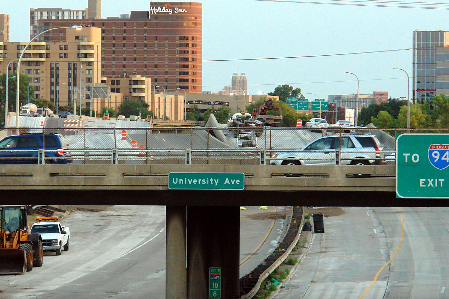
You can see where the road pivoted away with the cars of the closest calls of all balanced on the pivot point. Across the river you can see a semi-truck and some construction equipment on the south approaches to the bridge. It's the stuff in between that's missing. In the foreground is University Avenue; we know a person who got off there (frustrated with the traffic) five minutes before the collapse. Like I said, our 15 to 20-minute miss seems plenty big compared to these.
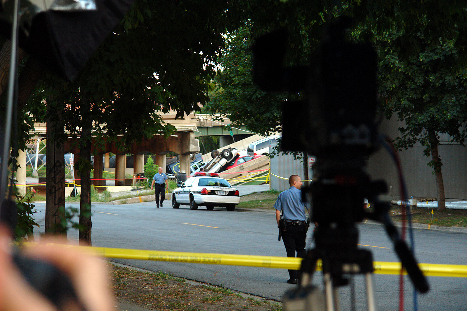
Down by Metalmatic at 2nd Street and 8th Avenue there was a view down between the factory on the left and the condos on the right. The is the north approaches to the bridge, not part of the main truss system, but the southbound lanes were pulled from their piers and there was a pileup, as you can see. This was a popular photo spot and there were some tv stations nearby.
I moved upstream. The power company now has some viewing walkways out into the river which I've never been on. These looked promising, and I rode out. Couldn't see a damn thing. I came back to shore and rode up to Nicolet Island, crossed the river, and headed back down towards the Guthrie. I went by the Mill Ruins Museum.
Boy, they're right on top of things! Actually, this is the Mill Ruins Museum, but it's very close to the bridge just upstream.
Probably the Guthrie's cantilevered bridge offers a nice view (we watched fireworks from it on July 4 after seeing 1776 with an aunt from England) but they're not letting the great unwashed out to gawk. (I like how we mere citizens "gawk" while politicians "inspect", "visit" and "survey"). The bike path which used to go under the I-35W bridge is of course closed off, so I moved over to Washington, crossed the abandoned freeway, and moved in behind some apartments. Bingo!
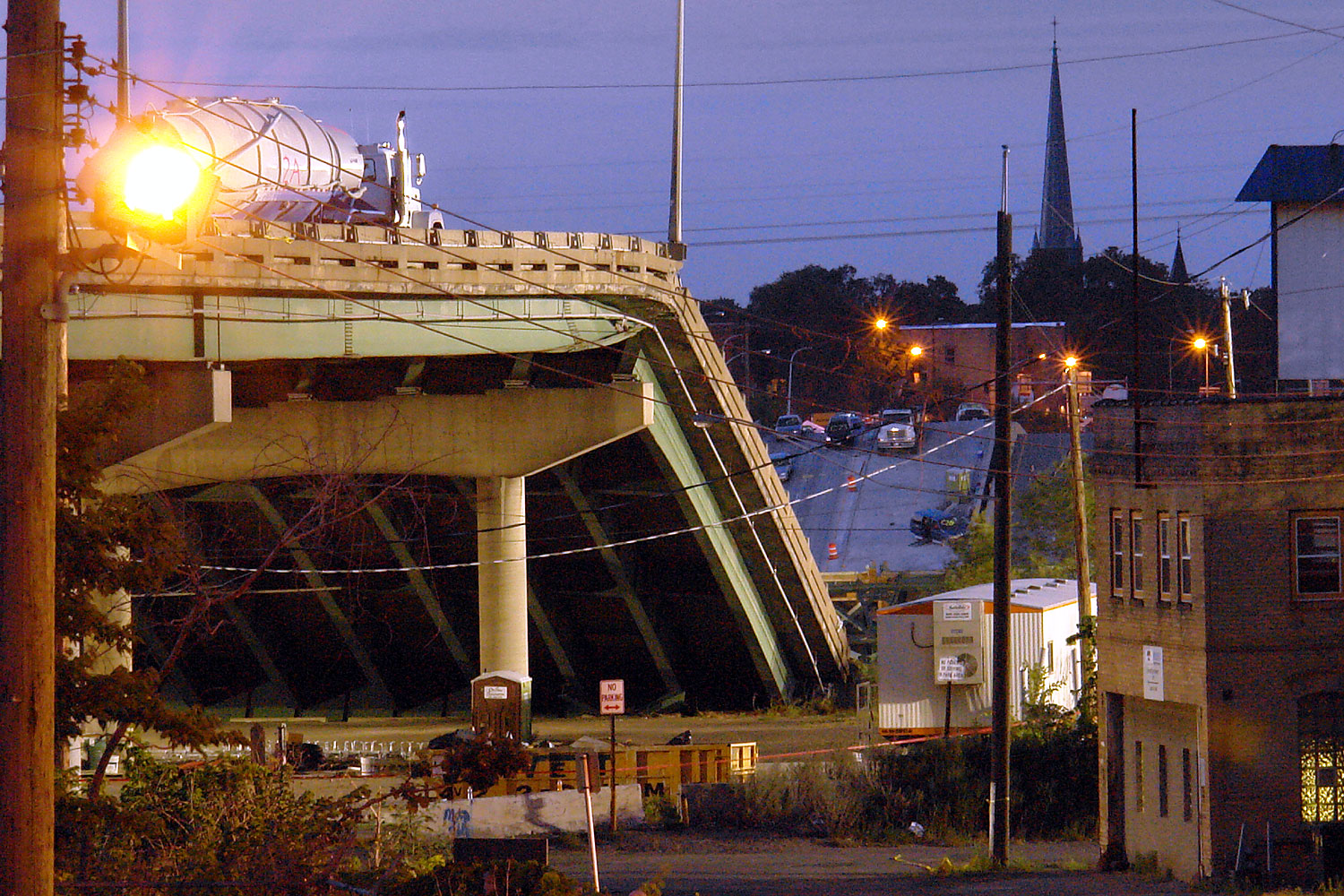
The semi from the first picture is the one on the left on this photo. This is from a parking lot of an apartment complex between 19th Avenue South and the Interstate. This is an odd bit of Minneapolis--the bridge paralleling the collapsed I35W bridge is called the 10th Avenue bridge, and on the north side of the river the street is 10th Avenue Southeast. On this side of the river, the street is called 19th Avenue South. Why it changes names I don't know.
Anyway, this 10th Avenue Bridge must offer spectacular views. Driving Wednesday to the concert, what residual journalism instincts I have (I started out as a journalism major) cried out to go home, get a camera and bicycle and get down there before everything got closed down. The 10th Avenue bridge is where I would have gone, but of course now it's closed. Officially it's due to concerns about it's integrity vis a vis debris from the collapsed bridge but really this would be one continual spectator stream made worse by the lack of a sidewalk on the upstream side (there is a very nice one on the downstream side). The bright light arrays they had up even as we came home from that Wednesday concert are on this bridge and I expect it will be some time before it reopens.
The light was fading and here, by the north end of the Number 9 bridge, the opposite end of which I'd begun my evening's viewing attempts, I'd made the full circuit. I rode into the U campus looking to take the Washington Avenue bridge home. I was at the lower deck level, not the upper deck, and the ramp up was closed, so I went into the building, took the elevator up one floor, and came out. As I got on the bike, a campus cop guy came over and told me firmly not to do that, that I should go around the building. Look, I said, I tried to use the ramp but it's closed and I don't know my way around. You need to go around next time he says firmly. Yes sir I'll keep that in mind. Sheesh, put these bozos in a blue shirt and badge and they're really feeling their oats, all this hero talk is getting to even the kampus kops.
I rode home using the Intercampus Transitway. It's a bit disrupted right now with road construction and work on the new Gophers Stadium. A big huge grain elevator that used to be there is gone now, and prep work is going on all over.
Bicycles are a great way to do this stuff. I basically never ride on sidewalks or the wrong way down one-way streets but did this night, in a situation like this it works wonderfully. In a car you can't get near anything, you get stuck in traffic, you can't see shit and there's nowhere to park. On foot, you're slow. On a bike, you can make good time, get most anywhere, transition from roadway to sidewalk to parking lot to pedestrian overpass seamlessly. You can even take the elevator up a floor in buildings at the U. You can see what's happening. I've done this before, many years ago during flooding in Des Moines, and just in recent weeks bicycles were of great utility in Japan after some earthquakes and in Britain during some flooding.
One irony of this bridge is how invisible it always was. It was as unremarkable and utilitarian a structure as they come, you only saw it when you drove over it, it had no real redeeming look to it. From the Number 9 bridge it was obscured by the 10th Avenue bridge, from the Stone Arch bridge, it's light truss structure was dominated by the same 10th Avenue bridge in background. Once the wreckage is cleared out, there won't a visual hole in the scenery like the missing World Trade Center towers.
Bicycling Implications
The collapse doesn't directly affect any bicycle routes since there was no bicycle or pedestrian facility on the bridge. As I mentioned earlier, a couple of very useful bike/ped routes are currently closed off but I expect that won't last. The most direct effect is likely to be increased street traffic until a new bridge is built.
However, old, deteriorated bridges have been the topic of conversation elsewhere. Only about 6 weeks ago there was a rally about reopening the Cedar Avenue bridge over the Minnesota river, which would be extremely useful to cyclists down there. Without going back and rereading the articles, I recall comments about how rotten the metal on that bridge is. I'm guessing that will be viewed with more concern now that before even if the loading is just bicycles and pedestrians. A new bridge might be in order rather than a restoration and as usual their are about fourteen agencies who have some say in the effort (for instance, it's close to the airport and any new bridge might have to support emergency vehicles in the event of a plane crash, etc.).
Separately, the wonderful Midtown Greenway across Minneapolis currently terminates at the river. There is this great big lovely railway bridge (the Short Line Bridge) that crosses the river. It used to have 2 tracks, now it has one, and it just serves a spur up and down Hiawatha. The railway has no interest in letting the county use the other bit for a bike path. There are various reasons, but in essence I think the railway has on its hands a big old rusty bridge (nobody seems to know exactly when it was built, but it was around 1880) serving a few grain elevators and scrapyards. I personally think that they look at this customer base, at the rapid improvements along Hiawatha due to the Light Rail which runs the other side, and figure that within a decade all these elevators will close down and they can abandon the spur and bridge. If they allow some stupid bikepath to go over it and all of a sudden it's being used by 3,000 people a day to get to work they now have to maintain their big old rusty bridge forever. Amid all this are discussions of the bridge's integrity and along the line was a comment that it's a design where you remove one element and the whole thing would come down. Again, I expect there will renewed sensitivity to that argument and that we will never see a bikepath on that structure, which is a real pity.
Other Bridgework
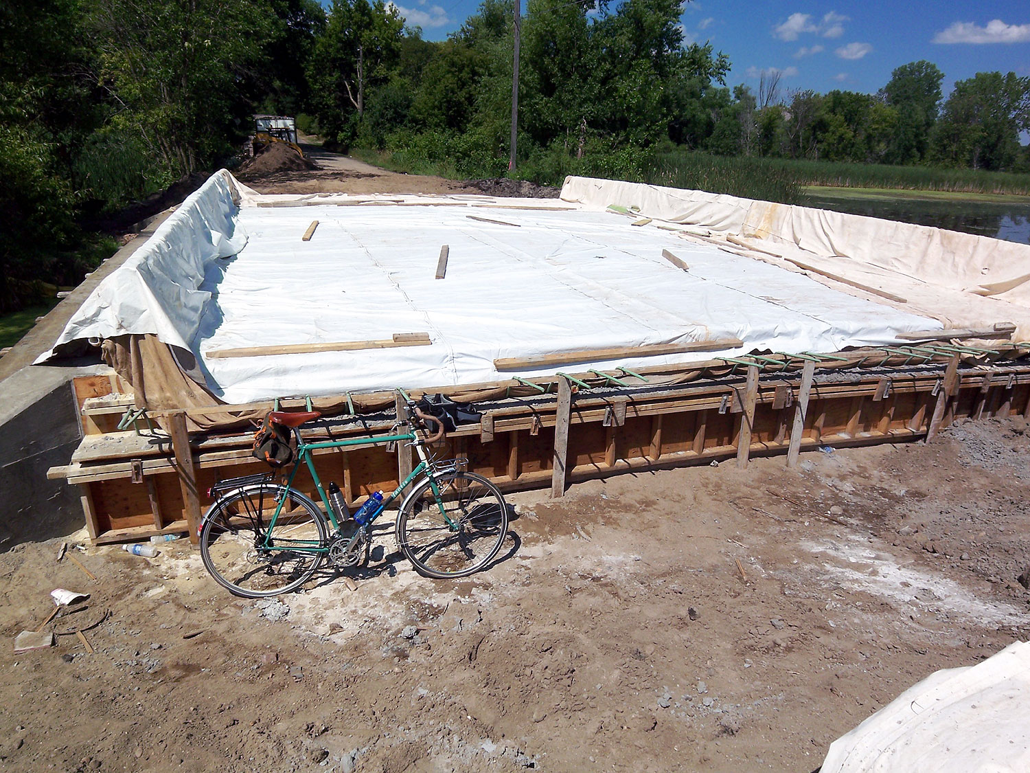
Ironically enough, I took some photos of bridge construction last weekend. Henry and I rode to Baker Park, in Western Hennepin County, to camp for a couple of nights with a bunch of church folks. Our late departure (5:35 from home) kept us from dawdling and taking pictures on the way out. We rode down Roselawn and wanted to cross Highway 280 to Broadway but even before the I-35W bridge collapse traffic volumes on 280 were up and no gaps presented themselves, so we went down to Hennepin and moved over. We took Broadway all the way from Industrial Boulevard to Golden Valley Parkway, including an unlovely bit of urban landscape in North Minneapolis, worked our way to Medicine Lake and took the Luce Line trail out to the park to camp by Lake Independence. It was about 33 miles altogether and if our 9:15 arrival sounds late it's because of stopping to navigate, get snacks and buy groceries.
Saturday Henry hung around the campground with the kids. I rode the Luce Line out to Watertown, then up to Delano and Rockford. I'd lost my mirror off my helmet last night and am unused to riding without one, so this felt odd to me. I ate a burger and a beer in Finnegan's in Delano and it wasn't very good. I'd gone in because they had a Boddington's sign in the window, but the didn't actually serve Boddington's. I had a Newcastle Brown Ale and a greasy half-pound hamburger with some bad fries. At least the service was indifferent. From Rockford I rode back to the campground, stopping to snooze for a while under a tree in front of a church. This was about 37 miles in all. Henry was taken home that evening as a bunch of the kids were going to Valleyfair on Sunday after church.
Sunday I got up, packed up and one of the other folks said, hey, we'll take your bags for you. I'm lazy, so I said OK, and they took the tent/pad/bag and both panniers, leaving me light and carefree to ride home. I rode the bikepath through the park to get to the connector back to the Luce Line. This marker was along the way:
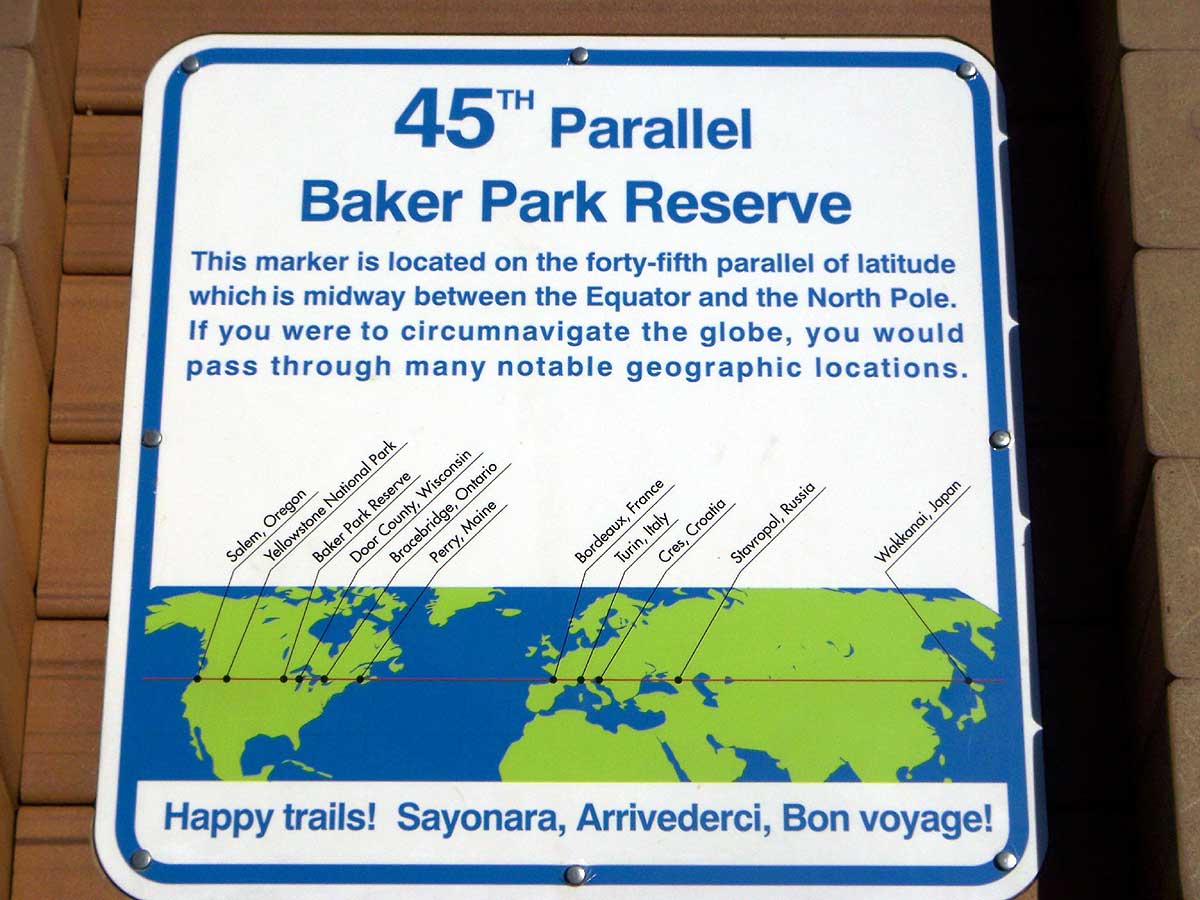
I was once in Yellowstone and there was a bunch of cars gathered along the road and it turned out to be a marker of the 45th parallel, halfway to the North Pole!, we took photos, etc., and then I discovered that in fact it runs right down Draper Avenue in Roseville and that I cross it every day going to and from work, usually refraining from stopping to take a photo. Anyway, these markers amuse me.
For those of you following along at home, I went south down Crystal Bay Road to Fox Road, and headed east. I was planning to go through downtown Wayzata. Along the way, Fox Road had a sign about ROAD CLOSED and BRIDGE WORK AHEAD. I ambled along, wondering if it was closed to everyone or just to mere motor vehicles. A cyclist came the other way and I called to him, Can you get through? We circled in the street a couple of times. Yep, he said, they're making a new bridge but you can kind of walk along the side. Last week you couldn't get by. Ok, thanks, I said. Hey, he said, nice Atlantis, I've got one too. Thanks, I sure like mine. And off I went.
The bridge over a little creek was being built but looking pretty impassable. He'd mentioned walking along the side and I looked around. Sure enough, there was a platform on the south side, probably for the workers. I lifted the bike up there and walked gingerly across. One false move and I could be pitched in excess of two feet into the murky waters below!

The walkway I used to get across.
The Atlantis in Exploring Mode--saddlebag, handlebar bag, ice water in seat tube water bottle. It held gin and tonics on the way out. This is on the east side of the bridge after my successful crossing.
I made it without incident, and rode on. On Peavey Road there was another ROAD CLOSED situation. It was half a mile ahead, so I figured it wouldn't cost me more than a mile total, and rode down. Another cyclist caught up to me (not an unusual situation). He's a local, and wasn't sure if it was open yet or not. This road was oozing money, driveways more expensive than my house, big estates, boats. The bridge, however, was impassable this time, and we turned back. I chatted with the other cyclist a bit, he directed me the way to Wayzata, and off I went. I stopped along the waterfront for a bit, munching peanut M&Ms, admiring the expensive cars, the expensive boats, the expensive women, even a remarkably riveting pair of expensive boobs, before riding on. I went past the Cargill headquarters, lost back in some woods, made my way down to Hopkins where I ate at a Chipotle, then rode on the Kenilworth Trail into Minneapolis.
My left crank arm was making noise, so I popped into Calhoun Cycle but there was no mechanic on duty and in fact I helped a customer who wanted to raise his stem and who thought he needed to loosen his headset locknuts to do it. I also bought a replacement mirror for my helmet. I moved on to Sunrise Cyclery where the owner quickly figured out my pedal was just loose, tightened her up, and the bike was once again silent running. Some Twin Cities Bicycling Club guys were there about to go on a ride, but they were heading out to Hopkins and I'd just been there, so I moved on. I took the Greenway to the river, crossed at Lake Street and headed home, about 38 miles total, a beautiful day for a ride.
2 comments:
Nice summary. Actually, though, the bridge collapse does affect a couple bike routes. It collapsed on top of the west river road which I used to take to work everyday and 2nd St. SE which I sometimes took as an alternate. I'd stopped going down the west river road lately, partly because it was so disconcerting going under I35 while the jackhammers were banging away directly above.
You are right. I was thinking in context of getting across the river rather than along it, and both 2nd Street SE (under the north approach ramps) and the West River Bikepath (under the south ones) are blocked and are likely to remain so until the new bridge is done. Looking at my bike map, it looks like there are easy workarounds for the 2nd Street SE blockage but the West River Bikepath doesn't appear to have great nearby alternatives.
Post a Comment